
Introduction: The Critical Role of SLAM in Robotics
Simultaneous Localization and Mapping (SLAM) is one of the core technologies enabling autonomous robots to navigate and understand their environment. By constructing a map while simultaneously tracking its position within that map, SLAM allows robots to operate without external positioning systems like GPS, a crucial capability for indoor, underground, or GPS-denied environments.
SLAM has evolved significantly over the past two decades, incorporating advances in computer vision, LiDAR sensing, and artificial intelligence. The primary approaches today are:
- Visual SLAM (vSLAM): Utilizing cameras as the main sensor
- LiDAR SLAM: Employing laser rangefinders for high-precision mapping
- Deep Learning SLAM: Leveraging neural networks to improve perception, loop closure, and mapping robustness
This article provides an in-depth comparative analysis, explores their respective principles, advantages, and limitations, and outlines optimization strategies for deploying SLAM in modern robotic systems.
1. Fundamentals of SLAM
1.1 The SLAM Problem
The SLAM problem can be formalized as estimating a robot’s trajectory X={x1,x2,…,xt}X = \{x_1, x_2, …, x_t\}X={x1,x2,…,xt} and building a map of the environment MMM simultaneously from noisy sensor measurements Z={z1,z2,…,zt} and control inputs U={u1,u2,…,ut}.
Key components:
- Localization: Determining the robot’s position and orientation
- Mapping: Building a consistent representation of the environment
- Data Association: Matching observed features to map landmarks
- Loop Closure: Detecting previously visited areas to reduce accumulated errors
Mathematically, SLAM often involves probabilistic formulations such as Extended Kalman Filters (EKF), Particle Filters, and Graph-based optimization, which estimate the posterior distribution P(X,M∣Z,U).
1.2 Challenges in SLAM
- Sensor noise and measurement uncertainty
- Dynamic environments with moving obstacles
- Real-time computation constraints
- Scale and feature sparsity in large environments
Addressing these challenges requires careful selection of sensors, algorithms, and optimization strategies.
2. Visual SLAM (vSLAM)
2.1 Principle
Visual SLAM relies on cameras to perceive the environment, extracting features or direct pixel intensities to build a map and track motion. It can be further categorized into:
- Feature-based SLAM: Detects keypoints (ORB, SIFT, SURF) and tracks them across frames
- Direct SLAM: Uses image intensities directly to estimate camera motion (e.g., LSD-SLAM, DSO)
The workflow generally includes:
- Feature extraction or direct image alignment
- Pose estimation via PnP (Perspective-n-Point) or optimization techniques
- Map generation using triangulation or dense reconstruction
- Loop closure detection for drift correction
2.2 Advantages
- Low-cost sensors (monocular or stereo cameras)
- Rich environmental information (color, texture)
- Lightweight hardware implementation possible on embedded devices
2.3 Limitations
- Sensitive to lighting changes, motion blur, and occlusions
- Scale ambiguity in monocular setups
- Requires high computational resources for dense reconstruction
2.4 Optimization Strategies
- Feature Selection: Use ORB or AKAZE features for speed and robustness
- Multi-Camera Fusion: Combine monocular or stereo cameras for scale estimation
- Bundle Adjustment: Globally optimize camera poses and landmarks
- Sensor Fusion: Integrate IMU (Visual-Inertial SLAM) for improved accuracy under fast motion
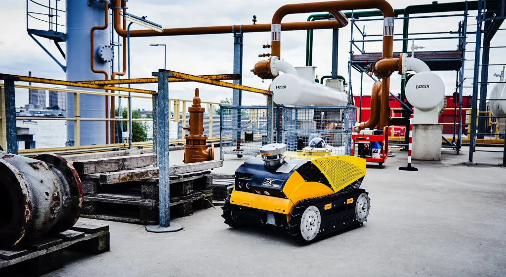
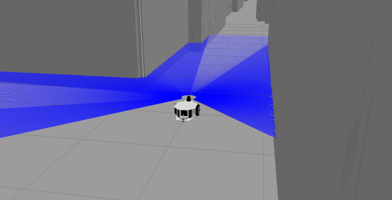
3. LiDAR SLAM
3.1 Principle
LiDAR SLAM uses laser rangefinders to measure distances and create 3D point clouds. It is particularly effective for precision mapping in structured and large-scale environments.
Key techniques include:
- ICP (Iterative Closest Point): Aligns consecutive point clouds to estimate motion
- NDT (Normal Distribution Transform): Models point cloud distributions for robust alignment
- Graph-based Optimization: Minimizes global pose errors using loop closures
3.2 Advantages
- High accuracy and precision in distance measurement
- Works in low-light and featureless environments
- Robust to environmental texture and color variations
3.3 Limitations
- High-cost sensors compared to cameras
- High computational requirements for dense point cloud processing
- Larger physical footprint, making integration challenging in small robots
3.4 Optimization Strategies
- Voxel Grid Downsampling: Reduces point cloud size for faster computation
- Scan Matching with NDT: Increases robustness to noisy or sparse measurements
- Multi-Sensor Fusion: Combine LiDAR with IMU or camera data for improved pose estimation
- Loop Closure Detection: Use keyframe-based or scan-context methods to correct drift in long trajectories
4. Deep Learning SLAM
4.1 Principle
Deep Learning SLAM leverages neural networks to improve traditional SLAM pipelines or replace certain components entirely:
- Depth Estimation: CNNs predict dense depth maps from monocular images
- Pose Regression: End-to-end networks estimate relative motion
- Feature Learning: Learned descriptors replace hand-crafted features for matching
- Loop Closure Detection: Deep embeddings identify previously visited locations
Deep learning SLAM frameworks may combine supervised, self-supervised, or reinforcement learning approaches to enhance robustness in challenging environments.
4.2 Advantages
- Better generalization in feature-poor or dynamic scenes
- Robust to lighting changes and partial occlusions
- Capable of learning semantic information for semantic SLAM
4.3 Limitations
- High computational cost requiring GPUs or edge AI accelerators
- Data-hungry: requires extensive training datasets
- May be less interpretable than classical SLAM methods
4.4 Optimization Strategies
- Network Compression: Quantization and pruning for edge deployment
- Hybrid Approaches: Combine deep learning for perception with traditional graph-based optimization
- Self-Supervised Learning: Reduces reliance on labeled data and adapts to new environments
- Temporal Consistency: Use recurrent architectures (LSTM, GRU) to stabilize pose estimates
5. Comparative Analysis
| Aspect | Visual SLAM | LiDAR SLAM | Deep Learning SLAM |
|---|---|---|---|
| Sensor | Camera | LiDAR | Camera / LiDAR / Multi-modal |
| Accuracy | Medium (texture-dependent) | High | Medium to High (depends on training) |
| Environment Sensitivity | Lighting, motion blur | Minimal | Lighting, occlusions mitigated |
| Computational Cost | Low to medium | High | High |
| Scale Estimation | Stereo / Multi-view | Direct measurement | Learned or sensor fusion |
| Loop Closure | Feature matching | Scan matching / graph optimization | Learned embeddings |
6. Optimization Strategies Across SLAM Types
- Sensor Fusion: Combine cameras, LiDAR, and IMUs for robust and accurate localization
- Map Representation: Use sparse vs. dense maps based on application requirements
- Graph Optimization: Employ pose graph optimization to reduce cumulative errors
- Adaptive Feature Selection: Dynamically adjust features or keyframes to optimize computation
- Edge AI Deployment: Run deep learning SLAM models on edge devices for real-time inference
7. Applications
7.1 Autonomous Vehicles
- High-precision navigation using LiDAR SLAM
- Visual SLAM for urban perception and traffic sign recognition
- Deep learning SLAM for semantic understanding of dynamic environments
7.2 Service and Industrial Robots
- Indoor mapping and navigation with Visual SLAM
- Warehouse automation using LiDAR SLAM for obstacle avoidance
- Deep learning SLAM enables adaptation to varying lighting and unstructured layouts
7.3 Augmented and Virtual Reality
- Visual SLAM tracks devices and headsets for immersive experiences
- Dense mapping for realistic AR overlays
- Learning-based SLAM supports robust tracking in feature-sparse environments
7.4 Exploration Robotics
- LiDAR SLAM for subterranean or underwater mapping
- Visual SLAM in GPS-denied environments
- Deep learning SLAM for autonomous adaptation to unknown terrains
8. Future Directions
- Hybrid SLAM Systems: Combine visual, LiDAR, and learning-based approaches for optimal performance
- Edge AI Acceleration: Deploy deep learning SLAM on embedded AI processors for real-time applications
- Semantic SLAM: Integrate object recognition and scene understanding for task-oriented navigation
- Collaborative SLAM: Multi-robot SLAM networks for distributed mapping
- Self-Supervised and Online Learning: Reduce dependency on pre-collected datasets and enable lifelong adaptation
Conclusion
SLAM remains a cornerstone of modern robotics, enabling autonomous operation in complex environments. Each approach—visual, LiDAR, and deep learning SLAM—offers unique strengths and limitations:
- Visual SLAM: Lightweight and cost-effective but sensitive to environmental conditions
- LiDAR SLAM: Highly accurate and robust but costly and computationally demanding
- Deep Learning SLAM: Adaptive and robust to challenging scenarios but requires edge AI and training data
Optimizing SLAM systems involves careful sensor selection, algorithmic improvements, and hardware-software co-design. Hybrid solutions that leverage the best aspects of each approach, combined with edge AI and semantic perception, represent the future of high-performance autonomous robotics.
SLAM will continue to evolve, enabling robots to perceive, navigate, and interact with the world with unprecedented intelligence and precision.